 Muneendra Kumar Muneendra Kumar
PhD, Chief Geodesist (Retired),
US National Geospatial-
Intelligence Agency,
munismk@yahoo.com
|
Of course, it would be extremely
rare, when any GPS surveying and/
or navigating to the North Pole is
undertaken. One such opportunity
occurred In April 2005. British explorer
Tom Avery in his effort(s) to recreate Adm. Robert Pearys epic journey of April 1909 to
North Pole took GPS to navigate himself.
During his journey, Averys team observed the GPS surveyed positions from the starting
point, enroute, near the extreme vicinity, and at the North Pole (Note: Unfortunately, no
repeat and along the return tracking observations were made). These geodetic positions
have allowed examining GPS surveying performance near and at the North Pole.
As the GPS positions appear at two places in Averys book (To the End of the Earth,
St. Martins Press, NY, 2009), 8 positions (near and at the Pole) have been copied
(Barclay Capitals Log and Page 271) into one table to produce a continuous sequence.
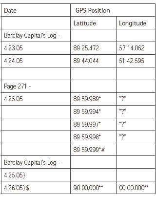
* These 5 positions are NOT in Barclay Capitals Log.
# The most northerly coordinate a GPS can register (As per comment on Page 271).
$ It is not clear How 1 position is attributed 2 days.
** In view of the remark (#) vide Page 271, from whom Barclay Capital logged this
latitude and longitude coordinates for the North Pole.
Un-Earthly Coordinates Did GPS survey the ZERO longitude, which does NOT
exists on the Earth, at the North Pole?
|
