| Geodesy | |
SIRGAS: Reference frame in Latin America
SIRGAS is the geocentric reference system for the Americas, by definition it is identical to the ITRS and realice the regional densification of the ITRF in Latin America which consist of the highest precision GNSS network in the continent called SIRGAS-CON |
 |
|
 |
|
 |
|
 |
|
 |
|
A brief introduction
Since its establishment 25 years ago, SIRGAS (Spanish acronym for Geocentric Reference System for the Americas) is the starting point in Latin America dealing with acquisition and treatment of geospatial information with scientific and technical features for applications beyond geodesy. Scopes and goals of SIRGAS have been showed in previous editions (e.g. Brunini and Sánchez, 2012; Fortes et al., 2006). Following to Cioce et al. (2018), this time is appropriate to share an overview about its evolution, consolidation and current role as an organization responsible for the maintenance of the continental geodetic reference frame, based on voluntary collaboration between governmental, academic and research entities.
Nowadays, SIRGAS is recognized as one of the better examples of international cooperation in regional geosciences, which came because of the imperative paradigm-change brought by the extensive use of the GPS (Global Positioning System) during 90s decade and the evident incompatibilities of the classical reference system at national level (i.e. PSAD56 and PSAD69) respect to the corresponding satellite techniques (i.e. WGS-84), degrading the quality of the coordinates determinations (IBGE, 1997). Under this circumstances SIRGAS was born as a project with focus on providing to the region of a well-defined reference system and frame, consistent with the satellite geodesy procedures. The challenge was proposed in 1993 during the International Conference for the Definition of a South American Geocentric Reference System held in Asuncion, Paraguay, organized by the IAG (International Association of Geodesy), PAIGH (Pan-american Institute for Geography and History) and NIMA (US National Imagery and Mapping Agency, now NGA, National Geospatial-Intelligence Agency).
In 2000, the UN (United Nations) recognized its achievements and SIRGAS became the reference system recommended for all countries in the Americas. This still is a valid fact taking in consideration the Resolution A/RES/69/266 approved in 2015 concerning to the GGRF (Global Geodetic Reference Frame) for Sustainable Development, because SIRGAS is the core geodetic infrastructure adopted and implemented by 20 countries, with solid foundations as member of the IAG Subcommission 1.3 (Regional Reference Frames), also SIRGAS is a Working Group of the Cartographic Commission of the PAIGH and supports the activities of the UN Regional Committee for the Global Geospatial Information Management (UN-GGIM: Americas).
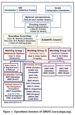
Regarding this, more than 50 entities located in Latin American countries assume scientific and technical responsibilities for developing activities organized by the three SIRGAS Working Groups, allowing the accomplishment of its goals: to provide a highly accurate geodetic reference frame consistent at global level in the geometrical and physical sense, to promote the implementation of the geospatial data infrastructure based on SIRGAS as core layer, and to contribute with geodetic observation of the Global Change. The SIRGAS structure is illustrated in the Figure 1.
The Latin American reference frame
Every activity executed for satisfying requirements of position, navigation and timing through and explicit use of GNSS (Global Navigation Satellite Systems) mandatorily need a global reference system to make a homogeneous and feasible relationship between observations and products to be obtained (e.g. coordinates). This is why SIRGAS exists in the region. It defines itself as a reference system identical to the ITRS (International Terrestrial Reference System) and its realization is the continental densification of the ITRF (International Terrestrial Reference Frame). In the SIRGAS countries, the access to the system/frame is possible by different national densifications that exists.
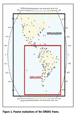
The SIRGAS reference frame was established in 1995 after the first GPS campaign over a geodetic network composed by 58 stations distributed only in South America, five years later, this network was extended to Central and North America reaching 184 stations (see Figure 2). The accuracy of the coordinates for both passive realizations was estimated in ±3mm y ±6mm (www.sirgas.org).
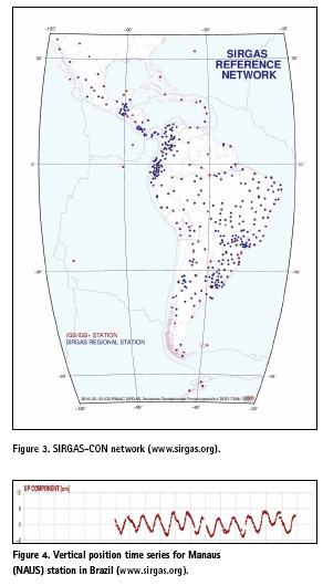
At present, a high precision geodetic network composed by 420 continuously operating GNSS stations and called SIRGAS-CON (Continuously Operating Network) represents the third and current realization of the continental reference frame (Figure 3). Thanks to the national cartographic agencies, universities and research centres dedicated to operate GNSS stations in every country, their data are available for the SIRGAS purposes. With recent updating process in the instrumental array, now the stations network gradually acquired capacities for multi-constellation tracking, i.e. GPS, GLONASS, Galileo and BeiDou.
This continuous GNSS network brings the access to the geocentric reference system/frame supporting a broad spectrum of geosciences applications in every Latin American country. The SIRGAS Working Group I (Reference System) is responsible for assuring the suitable maintenance of the continental densification of the frame through a weekly processing of the GPS and GLONASS observations made by all the stations. A rigorous strategy of geodetic estimation according to the current conventions and standards from IERS (International Earth Rotation and Reference System Service) and IGS (International GNSS Service) is applied homogeneously by the SIRGAS Analysis Centres (10 Processing Centres and 2 Combination Centres), offering an upto- date reference frame.
Formerly, the SIRGASCON processing was performed by DGFI-TUM (Deutsches Geodätisches Forschungsinstitut der Technical Universität Munchen), because since 1996 it is the IGS RNAAC SIRGAS (IGS Regional Network Associate Analysis Centre for SIRGAS). Its grateful contribution to the SIRGAS consolidation allowed the installation of the other nine centres operated by Latin American institutions, these are: LUZ (Universidad del Zulia, Venezuela), IBGE (Instituto Brasileiro de Geografia e Estatística, Brazil), IGNEc (Instituto Geográfico Militar de Ecuador), UNA (Universidad Nacional de Costa Rica), IGAC (Instituto Geográfico Agustín Codazzi, Colombia), IGM-Ch (Instituto Geográfico Militar de Chile), IGNAr (Instituto Geográfico Nacional de Argentina), INEGI (Instituto Nacional de Estadística y Geografía, México), SGM (Servicio Geográfico Militar, Uruguay).
Each Processing Centre generates loosely-constrained weekly solutions of the network, DGFI-TUM is in charge of the continental set (SIRGAS-CON C), i.e. stations that directly densify the ITRF in the region; local centres assume the processing of the national sets (SIRGAS-CON N). Both Combination Centres (IBGE and DGFI-TUM) offer the weekly solutions aligned to the ITRF also contributing with the IGS global polyhedron determination. Based on inner and outer controls of the results an accuracy of ±1mm for horizontal position and ±3mm for the vertical one is achieved.
Consistent coordinates, updated, accurate and useful for…
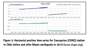
Accurate geospatial information is a basic requirement for modern society and this is the engine driving the optimization of the geodetic reference systems and frames, this fact has impacts on the observation technique improvements like GNSS, so they have enough precision for sensing those almost imperceptible positions changes which attempt against the geodetic infrastructure stability at any level such as the occurrence of secular, sporadic and seasonal phenomena (e.g. tectonics, earthquakes and hydrological effects respectively), and even those induced by measurement environment disturbances like receiver-antenna changes. Figures 4 and 5 show two emblematic cases: the 2010 Maule earthquake in Chile and vertical variations at stations located in Amazonia. Because of the complex geodynamics in Latin America and considering to SIRGAS as the unique provider of the reference frame aligned to the ITRF, the weekly processing of SIRGAS-CON is strongly needed.
The high accuracy and global consistency of the weekly solutions benefits to the final users in the region who require an accessible, steady and compatible reference frame with respect to GNSS orbits, a basic product for positioning. These also support the homogeneous treatment of geospatial information despite its features since every SIRGAS country speak the same language (in analogy to the reference system) but using different realization and epochs.
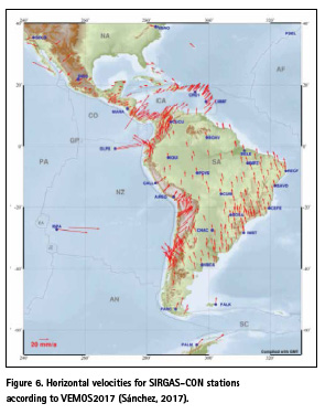
From the scientific perspective, monitoring and improving of SIRGAS-CON are given by results with uniform temporal resolution, multi-year solutions are then the key products that define a long-term reference frame, its kinematics can be analyzed for estimating not only stations positions but velocities as fundamental element of any modern geodetic frame. In addition, SIRGAS develop its velocity model valid for Latin American region and useful to translate the observation epoch of the coordinates, in special for GNSS positioning tasks based on passive networks. Both products, multi-year solutions and velocity models, are calculated for regular intervals. Most recent are SIR17P01 (Sánchez, 2017) and VEMOS2017 (Drewes and Sánchez, 2017) respectively. The current velocities for SIRGAS stations are illustrated in Figure 6.
Another relevant aspect of the continuously processing of the SIRGAS-CON network is the real possibility to conduct studies about geodetic-geophysical phenomena very crucial for the reference frame optimization and Earth System understanding, for example the crust deformation modelling caused by seismic events and hydrological load, and atmospheric activity monitoring at ionosphere and neutral atmosphere levels. In this sense, SIRGAS-CON defines a framework for geosciences in Latin America and promotes the GGRF implementation satisfying its geometrical component for positioning, navigation, geomatics, resources and risks management, global change monitoring and administration of geospatial information for the society according to UN goals for sustainable development.
SIRGAS in practice
Having a solid geodetic infrastructure as SIRGAS implies significant advantages for Latin American countries. As mentioned before, each nation assumes same system but different realization and reference epoch. This is the reason why it is essential the designing and application of methodologies for an optimal exploitation of those benefits being responsibility of the SIRGAS Working Group II (National Level) which promotes and support the SIRGAS adoption in the region by means of guidelines and permanent recommendations pointing to the installation and maintenance of continuously operating GNSS network for precise positioning purposes and reference frame densification at local (national) level.
Actions drived for the working group are ruled by capacity buildings needs in the member countries and they are reflected in terms of divulgation of scientific and technological concepts related to the practical implementation of the reference systems and frames. This goals are successfully achieved since 2009 through periodic training activities thanks to the SIRGAS Schools sponsored by the IAG and PAIGH.
By the other hand, experiences during past years demonstrate how the user request of geodetic positioning for any application and the availability of SIRGAS as high-precision reference frame match in the Real Time GNSS technologies; it is not a casual coincidence, receivers upgrade on SIRGAS-CON stations are bringing capabilities for generating and transmitting differential corrections even by Internet following the NTRIP (Networked Transport of RTCM via Internet Protocol) protocol.
Some remarkable examples are the national densifications in Brazil and Uruguay with continuously and also actives GNSS stations. Real-time observations under NTRIP supporting had been studied and implemented in other SIRGAS countries (see examples at www.sirgas.org/en/presentations), so the region counts with a caster-school for facilitating to any user the approaching to the real time infrastructure defined by the active GNSS station, all of them under the SIRGAS-CON umbrella.
What about the vertical reference system?
One of the major topics for modern geodesy is dedicated to defining and establishing the vertical reference system and frame being this updated, unified and global, i.e. the IHRS (International Height Reference System) and IHRF (International Height Reference Frame), both are the complement of the GGRS/ GGRF conceptualization. In 2015 the IAG resolved that IHRS is given in the geopotential domain with geopotential numbers (Cp) as vertical coordinates respect to the conventional geoidal potential value W0 and spatial reference from cartesian-geocentric coordinates (X, Y, Z) respect to ITRF (Drewes et al., 2016).
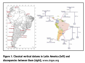
Heterogeneities and discrepancies between the multiples classical height reference systems (Figure 7) adopted in Latin America at 1950 decade are the major drawbacks for vertical datum modernization according to GGRS/GGRF. By an appropriate integration of those local systems to the IHRS is possible to update the available vertical data, making them useful for geodetic applications in the global context (Sánchez and Sideris, 2017). The SIRGAS Working Group III (Vertical Datum) is promoting and developing since 1997 some activities for achieving the unification of the vertical systems in Latin America in order to reach the IHRS definition.
Some of those activities are the unified adjustment for the national classic levelling networks empathizing borders inter-connections, the absolute and relative gravity networks densifications, and evaluations of GGM (Global Geopotential Model) and Satellite Altimetry products. Currently, there is strengths in the region and remarkable milestones demonstrating the progressive approach to the IHRS/IHRF. The realization and processing of the vertical networks in the geopotential domain together their linking with the geometrical component of SIRGAS (i.e. SIRGAS-CON stations) are being executed. Besides, SIRGAS had proposed a set of GNSS stations for serving as the continental densification of the IHRF.
Closing remarks
In Latin America any scientific and technical application based on geodetic positioning find in SIRGAS the suitable support in terms of the high-precision reference frame aligned to the ITRF. The efforts and mutual cooperation between the member countries made possible the maintenance, operation and weekly processing of GNSS observations from the SIRGAS-CON network, and the highest precision products (geodetic positions) such as loosely-constrain, adjusted and multi-year solutions guarantee the geospatial information consistency in the region.
SIRGAS expertise during the last 25 years definitely contributes with the continental geodesy developments ruled by proper guidelines and recommendations for the Latin American nations which had adopted to SIRGAS as reference system and now are looking to the establishment and implementation of the GGRF. There is no doubt that this is a successful example of international cooperation.
Beyond of the achievements and considering implications related to the GGRF, SIRGAS is working on the optimization of its continuously operating GNSS network, its practical use and unification of the vertical datum for assuring reference frame high accuracy and consistency without neglecting in the coming years a possible approaching to other geodetic techniques like VLBI (Very Long Baseline Interferometry) or SLR (Satellite Laser Ranging).
References
Brunini C. and Sánchez L. (2012). Geodetic activities in Latin America and The Caribbean: always in. Coordinates. Vol. 8. Issue 6.
Cioce V., Martínez W., Mackern M.V., Pérez R., de Freitas S. (2018). Supporting GNSS application in Latin America through the SIRGAS Reference Frame. United Nations/Argentina Workshop on the Applications of GNSS. Falda del Carmen, Argentina.
Drewes H. and Sánchez L. (2017). The varying surface kinematics in Latin America: VEMOS 2009, 2015, and 2017. SIRGAS Symposium 2017. Mendoza, Argentina. Available at: www.sirgas.org Drewes H., Kuglitsch F., Ádám J., Rózsa S. (2016). The Geodesist’s Handbook 2016. Journal of Geodesy. Vol. 90. Issue 10.
Fortes L.P., Lauría E., Brunini C., Amaya W., Sánchez L., Drewes H., Seemüller W. (2006). SIRGAS – a geodetic enterprise. Vol. 2. Issue 5.
IBGE (1997). SIRGAS Relatório Final – Grupos de Trabalho I e II. Available at: www.sirgas.org
Sánchez L. (2017). Kinematics of the SIRGAS reference frame. SIRGAS Symposium 2017. Mendoza, Argentina. Available at: www.sirgas.org
Sánchez L. and Sideris M. (2017). Vertical datum unification for the International Height Reference System (IHRS). Geophysical Journal International. Vol. 209. doi: 10.1093/gji/ggx025


 (No Ratings Yet)


Leave your response!